

Flooding causes delays on Tube and roads are left underwater in London and Essex
‘Biblical’ downpours spark rush hour chaos: Flooding causes severe delays on the Tube and roads are left underwater in London and Essex as severe weather warning is issued with up to three inches set to fall today
Heavy downpours of rain caused disruption to road and transport networks across parts of UK this morningPhotos and videos shared by commuters this morning show travel chaos caused by flooding in some areasWeather warnings are in place with the Met Office predicting some areas of UK could see up to 50mm of rain
<!–
<!–
<!–<!–
<!–
(function (src, d, tag){
var s = d.createElement(tag), prev = d.getElementsByTagName(tag)[0];
s.src = src;
prev.parentNode.insertBefore(s, prev);
}(“https://www.dailymail.co.uk/static/gunther/1.17.0/async_bundle–.js”, document, “script”));
<!–
DM.loadCSS(“https://www.dailymail.co.uk/static/gunther/gunther-2159/video_bundle–.css”);
<!–
Biblical downpours have battered parts of Britain overnight leaving commuters facing travel chaos and flooded roads this morning as the Met Office warns some areas could see up to three inches of rain today.
Weather warnings are in place from the Met Office as downpours have caused flooding in parts of the country including London where the road and transport networks have been affected.
Forecasters say that St James’ Park in London has recorded 26mm or just more than an inch of rain in the space of an hour this morning while videos from the nearby Knightsbridge and Hammersmith areas show deep flooding affecting roads and businesses.
Meanwhile Transport for London (TfL) warned of severe delays on the circle and district lines this morning due to flooding which caused signalling problems.
On the Overground, the service has been suspended between Kensington (Olympia) and Clapham Junction due to flooding in the Imperial Wharf area.
Commuters in Essex described ‘biblical’ rainfall which has also caused major disruption to the C2C rail network.
The Met Office has confirmed that between midnight and 6am this morning, St James’ Park in London saw 35mm of rain while Storrington in West Sussex saw 30mm and Market Bosworth in Leicestershire recorded 29mm.
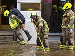
Commuters were left facing travel chaos this morning after a night of heavy rain left many parts of the country with flooding. Pictured: A woman is carried over flood water by a fireman in Knightsbridge, London, where the road was washed out
Pictured: A woman is carried over floodwater by a fireman in Knightsbridge as an amused pedestrian keeps his feet dry
Met Office issued two yellow weather warnings for rain which covered large parts of UK. Pictured: Flooding in Knightsbridge
The wet weather is expected to dry up by the end of the day but roads are still flooded in parts. Pictured: Flooding in London
The London Fire Brigade outside and inside SERENE as Flooding devastated businesses in Knightsbridge, central London
London was hit by torrential rain last night which meant commuters had to negotiate flooding and travel chaos this morning
Weather warnings are in place from the Met Office as downpours have caused flooding in parts of the country where the road and transport networks have been affected this morning. Pictured: Broken down car on a flooded underpass in Wandsworth
Commuters have been warned to allow extra time to travel due to flooding. Pictured: Flooding in Knightsbridge, London
Roads and businesses have been affected by flooding caused by heavy rain this morning. Pictured: Flooding in Knightsbridge
Commuters have been warned to expect disruption due to the poor weather which is set to clear by the end of the day before a spell of brighter weather throughout the rest of the week.
London Mayor Sadiq Khan said he was working with transport and council bosses to address flooding in the capital.
He said: ‘Londoners will be aware that flash flooding has impacted parts of our transport network. I’m in touch with who are working hard with local councils to open roads and return affected Tube and rail service to normal as quickly and safely as possible.
‘Once again, we’re seeing the impact of the climate emergency on our doorstep. In London we’re leading from the front to tackle this crisis, and I’ll continue to urge other politicians here and around the world to take the action that’s desperately needed.’
Ruairidh Roberts, UK Country Manager at Waze, said: ‘Heavy rainfall in London overnight has led to increased levels of traffic this morning, with roads and the Underground both affected by flooding. Average speeds are as low as 3mph in some areas, including Knightsbridge, Putney Heath and Blackheath.
‘Road closures, weather hazards and congestion levels are reflected on Waze’s live map. We encourage all drivers to check weather alerts and plan their journeys before setting off, and only travel if it is safe to do so.
Pictured: the A4 just past Hammersmith flyover after torrential downpours in London where some parts saw 30mm of rain
Flooding on Knightsbridge between Hyde Park Corner Underground and Knightsbridge underground, after heavy rain
‘If drivers do encounter difficulties, they can use the Roadside Assistance feature in the app to seek help.’
Forecasters predict persistent and at times heavy rain and strong winds for northern England and south-east Scotland while rain will clear to blustery showers and sunny spells in the south and west.
In a statement, the Met Office said: ‘Rain, accompanied with strengthening winds, will move north and eastwards across the area early on Tuesday, becoming slow-moving over parts of northeast England and, later, also eastern England.
’15-30 mm of rain is expected to fall quite widely. Over eastern and northeastern England, 40-50 mm of rain is likely to fall in some parts with 50-75 mm also possible in a few spots.’
From tomorrow, the Met Office said any early cloud and rain across eastern areas will clear bringing fine weather across Scotland, Wales and England during the day, predicting that it will be dry with lots of sunshine.
Thick cloud will build in from the west across Northern Ireland bringing rain which will spread into western Britain during the evening.
Crews from London Fire Brigade help clean up after heavy flooding in the capital where more than 30mm rain fell last night
The flooding had yet to subside in Knightsbridge, central London this morning as commuters continued to head in to work
Pictured: Traffic, firefighters and pedestrians caught up in flooding in Knightsbridge, central London, this morning
Pictured: Video captured in Kennington, London, this morning shows traffic negotiating flooded roads after heavy rain
Commuters faced severe delays this morning after heavy rain caused flooding and travel chaos. Pictured: Kennington
Pictured: Cars negotiate severe flooding in Knightsbridge this morning after heavy rain caused disruption across the capital
Major downpours hit large parts of the UK with St James’ Park in London recording 26mm in just one hours this morning
The balmy weather from mid-week will be driven by the remains of Hurricane Sam currently making a beeline for Britain.
The ex-storm system heading across the Atlantic will force high pressure over the UK, experts have said.
It will pull warm air in from the Continent pushing thermometers towards 70F by Thursday, forecasters say.
Ex-BBC and Met Office forecaster John Hammond said: ‘There will be talk of an Indian summer if Sam shoves warm southerly winds and a marked upturn in temperatures our way.’
Jim Dale, meteorologist for British Weather Services, said: ‘The remains of Sam are about to bring a change from the wind and rain to a very nice spell of balmy, sunny weather.
‘The ex-hurricane will move towards Iceland and will allow high pressure to build across Europe and over the UK as balmy air flows in from the south.
The Met Office has predicted that some parts of the country could see 50mm of rain today. Pictured: Knightsbridge, London
Pictured: Vehicles drive through a huge puddle in Bermondsey, London, after heavy rain caused flooding across the capital
The flooding across London comes after a wet summer which caused bouts of flooding across the capital in recent months
Pictured: Torrential downpour captured in Lincolnshire this morning as heavy rain moves east across the country today
Weather warnings have been issued by the Met Office for today (left) after heavy rain hit large parts of the UK (right)
Experts say Hurricane Sam (pictured) is moving across the Atlantic and will drive high pressure across Britain from mid week
‘Temperatures will be highest around Wednesday or Thursday. In the sunshine it may feel very warm, and it is safe to say we could be in for an Indian Summer.
‘This spell should last a few days, but the pattern could continue for longer, possibly into mid-month.’
Scotland and parts of north-eastern England will be warmer than southern Britain with highs of around 70F (21C).
London and the southeast could creep towards the 68F (20C) mark with above-average temperatures forecast nationwide.
However, Britons should grit their teeth for another blast of autumn in the run-up to mid-week.
Mr Dale said: ‘Low pressure will remain in charge through the start of the week and there will be more in the way of wind and rain.
‘Sam comes along on Wednesday and will move close to the jet stream before heading towards Iceland allowing high pressure to build from the Continent.
‘This will bring the change of weather with highs of 70F (21C) in north-east Scotland and parts of northern England, while elsewhere, it could reach 64 to 66F.
‘This Jekyll and Hyde weather is usual for October.’
![]()