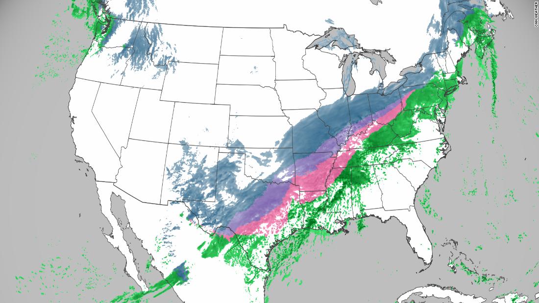
The biggest impact will be in the South where a crippling ice storm is likely, while parts of the Midwest could see more than a foot of snow
More than 85 million people are currently under winter weather alerts stretching from the Rockies to New England — over 2,000 miles.
The biggest impact will be in the South, where a crippling ice storm is likely. Places including Dallas and Memphis, Tennessee, could see icy roads and power outages amid dangerously cold temperatures.
Parts of the Midwest could see over a foot of snow; potentially the biggest snow in a century for some.
The winter storm is setting up first in the Rockies on Tuesday.
“Heavy snow will begin in the Rockies spreading across the Midwest on Tuesday night through Wednesday, where some areas could see 15 to 20 inches of snow,” said CNN meteorologist Dave Hennen.
The Midwest will actually have two rounds of winter weather — as if one round of brutal conditions wasn’t enough.
“Round 1 will arrive tonight and last through much of Wednesday,” said the National Weather Service office in Chicago. “Widespread snow totals of 8 to 12″ will make travel difficult if not dangerous.”
Chicago’s weather service office also indicated that snowfall rates could be up to an inch per hour at times, which will reduce visibility. Then round two will pass through the same region on Thursday, bringing up to an additional 6 inches of snow for some areas.
And if snow totals stack up the way models are suggesting, this will be a historic snowstorm.
The snow forecast for Fort Wayne, Indiana, is 18 inches. If that happens, it would tie the all-time snowfall record from 1900.
“Toledo could be looking at their biggest snowfall in 100 years,” said CNN meteorologist Brandon Miller. “The National Weather Service forecast is for 16 inches, which would rank second behind 20.2 inches in 1900.”
Potential significant ice storm for the South
The storm will the push south and east — where conditions could turn more icy than snowy with the threat of significant ice accumulation for millions.
“A corridor of heavy ice accumulation (exceeding a quarter of an inch) is likely from Texas through the Ohio Valley,” said the Weather Prediction Center.
From Dallas to Memphis, rain will begin Wednesday evening, then change over to a wintry mix on Thursday. However, impacts from this system could linger especially in the South and mid-South until Saturday or Sunday.
“The primary impact would be ice accumulation that may lead to very dangerous travel Thursday and Friday particularly on high-rise overpasses,” said the weather service office in Dallas/Fort Worth. “A quarter-inch or more of ice accumulation on utility lines and trees with winds gusting to 30 mph would likely lead to power outages and tree damage.”
While the highest ice totals will be north of the Dallas metroplex, the metroplex could see up to a quarter-inch of ice as well, leading to major disruptions in travel.
The wintry mix will eventually turn to all snow for the area on Thursday, which will all fall on a layer of ice — meaning the snow could ‘stick’ for several days. The reason for this will be the duration of freezing temperatures. The Dallas metroplex and surrounding around could see up to 3 inches of snow fall on Thursday.
“Dangerous wind chills as low as 5 below zero are forecast Thursday and Friday mornings,” the weather service office in Dallas/Fort Worth said. “Those that see significant ice accumulation would likely not rise above freezing until Sunday.” This will create a dangerous situation, especially for anyone who loses power.
For much of Tennessee and Kentucky, ice could be a big player with this system, crippling cities and disrupting travel.
The weather service office in Memphis said it is “very concerned with the icing issues” that this system could bring. “Looks very messy for the mid-South with several hours of freezing rain and sleet across the area. Some of the totals are downright nasty,” the weather service said.
The forecast for areas around Memphis are anywhere from a tenth of an inch of ice, up to a half inch of ice.
“This is a very conditional situation and any fluctuations in temperature or placement of the arctic front will be the difference in you seeing a very cold rain or a significant ice storm,” the weather service office in Memphis said.
Adding to the misery in Memphis, the area will be dealing with up to 3 inches of rain before the icing sets up. Localized flooding is possible during the rain portion of the event, then conditions will quickly turn to ice, followed by snow.
Another shot of winter for the Northeast
From there, the storm will drape across the Northeast and New England.
However, it will be another disruption for travel and bring another shot of cold air to the region — keeping all that snow on the ground even longer.
Rain will push into the Northeast and New England on Thursday evening, then a changeover is possible on Friday.
Expect a messy day along the Interstate 95 corridor for that region all day on Friday as this cold front pushes through.
Confidence is still low on how much winter precipitation will fall for this region, but it does look like areas inland will receive more winter weather than the big cities along the coast.
While all of this is subject to change, that prediction is based on the best guidance thus far.
What is more certain is the cold air along with this front. Temperatures will fall through the day on Friday, resulting in a cold weekend for millions. “Temperatures forecast on Friday start out in the lower 30s to lower 40s and by end of the day are forecast to be in the upper 20s to upper 30s,” said the weather service office in New York City.
![]()


